 One of the things I get paid for is looking at these old photographs. I'm usually looking for evidence of past landslides, or long-lost grading. But this was pure indulgence, culled from the files of the U.S. Army Corps of Engineers files during a long day of researching a nearby site.
Our little house is under the orange circle. Here's the same neighborhood today:
 Stop for a moment and compare the two images. That's okay, I'll wait a while.
The modern image is just what you'd expect; little brick (or in our case, wood) houses for you and me, right? That's my University Park neighborhood in a sentence, no different from any other urban Portland neighborhood. The big white-roofed building to the east? That's Astor Elementary, where the kiddos go to school. Go, Astor Eagles!
But look at the top image for a bit. Here; I'll give you a little bigger view of a portion of the southwest corner of the same photo:
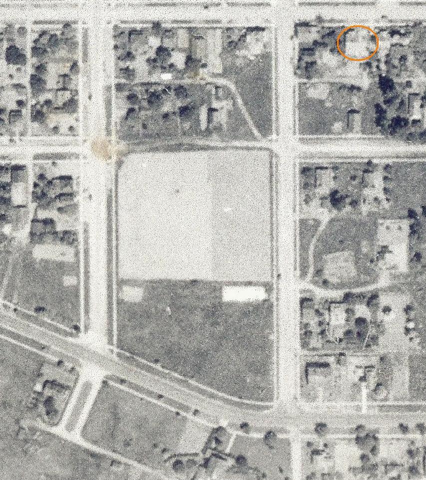 Our house (built only about fourteen years before the photo was flown) is still under the orange circle. We understand that the little building at the corner to the west was some sort of mom-and-pop corner store, selling Coke in bottles, and penny soap to the good working-class folks of Depression-era North Portland. And note a couple of other things; the big pale farm fields down a block to the west, with some sort of long white barn or shed along McKenna Street at the southeast corner. And notice all the little footpaths and tracks that meander through the center of the blocks; in a lot of ways this part of NoPo was still pretty rural in '36 - rural enough for folks to follow the old cowpaths rather than stay on the sidewalks.
OK, now here's an enlargement of the next Corps photo flown, from 1940:
 One thing I picked out here was the garage - that's inside the orange box. See it? The thing is, Portland City code requires you have a garage. No shit. Seriously. If you park your car on the street more than 48 hours you can be cited for something called "in lieu of garage" and that's a fineable offense.
Really.
So back in the day all Portland houses had garages. Ours did. But at some point prior to the 1960's the thing either burnt or rotted away and fell over. I've found bits of it under the backyard sod. But there it is in 1940, keeping the summer sun off someone's 1938 Ford Twodoor.
Here's the larger 1940 image. One thing - look at the color of the streets. See how dark they are? Now look back at 1936. See the difference?
 The thing is that the 1936 sidewalks look about the same color as the streets, and the streets themselves look too regular to be unpaved. See that curvy line above the farm field in both 1936 and 1940? That's N. Yale Street between McKenna and Wall, dirt then and dirt now. But the regular street grid looks paved - just not paved with asphalt. Y'know what I think happened?
I think the streets were paved in the late Teens and Twenties (when this portion of U-Park was first really developed) with concrete.
 That's surprisingly common for Portland; in many of the older neighborhoods in the inner East side you can still find some of those old concrete pavements exposed. But they're brittle, and usually end up covered with asphalt before too long. I think by 1940 the City had decided that they weren't going to pay for any more concrete and laid down the macadam on top.
 The funny thing is that when I started doing this sort of overhead window-peeping in the early Nineties there really wasn't any other way to do it; the information was either in the files at places like the Corps or proprietary to private aerial photo companies. But Google Earth and similar applications have changed all that dramatically. The image above is a larger-scale view of my home from GE, circa 1952.
Note that you can barely see Astor School, the larger H-shaped dark block east of the circle that marks our house, but the long arc of Mock's (or Waud's) Bluff, the steep cut bank of the old meander of the Willamette River that encloses Swan Island is easily seen.
 In the old photo you can see the "island" - the rectangular peninsula that projects up to the northwest. This had been used as Portland's airport in the earlies, and was just then beginning to be developed as the industrial area it is today - here it is in 1925, probably not long after Lindbergh visited.
 Note that in the aerial photo the Union Pacific line running towards the long tunnel under North Portland is still an embankment surrounded by wetlands. And here is the same view today;
 A little busier, isn't it?
The wetlands are gone, the swans are gone, the concrete streets are gone, the old farm fields, the cowpaths, the garages...all gone but where they remain crystallized forever in silver salts and black.
7 comments:
Chief,
and soon you'll be gone.
and so it goes.
jim
Not too soon, I hope. But maybe some yutz living in our house 60 years from now will be looking at the 2010 photo and will pick out the work WE did on the house and around our neighborhood.
It's not so much the going but what we leave behind us, neh?
Chief, nice detective work. I approve of your recent increased blogging activity.
BF: Glad you enjoyed it - it was fun to do as well as write up; that may be the cause of the sudden activity...
Interesting how the internet allows us to view the artifacts of our recent past lives, even as we are living them. We're both the archaeologist and the specimen.
Lisa: And, what's more, we've gone through this tremendous change in a tiny fraction of our lifetimes.
The internet has made this enormous change in how we know things and what we know. When I started using the Corps aerial photo library in the early 90's that was the only way to see this stuff, and only a tiny few of us knew where and how to view it.
Now you can Google Map yourself in a hearbeat, and Google Earth has historical photos back to the 40's and 50's so you can look back at the past...
Think of the way this has changed almost any sort of research. You used to have to know how to use a Dewey decimal card file, or how to use the Reader's Guide to Periodical Literature to find some printed resource. Now? Just Bing "volcaniclastic deposits The Dalles Oregon" and in a half a second you have 10,000 citations...
I think it's happened so gradually that we forget how dramatic that change is, but it really IS huge, and I wonder what the endpoint will turn out to be...
I wonder what the endpoint will turn out to be...
I wonder, as well. The change has been dramatically fast, actually. When I was in school, one needed recourse to microfiche to research old copy (and of course, some things are still only available that way), and databases like "Medline" were available for purchase. Now most are open source (or at least, the abstracts are.)
Newspapers are still fiddling around with charging for online content; the NYT has gone back and forth on this one. My big concern is the lack of privacy: When at the card catalog, no one knew what you were doing. Now, everything one does online is data mined.
In addition, one is left to one's own devices when trying to ascertain legitimate vs. other sources. Everything is so sped up, I fear we are losing the ability to properly synthesize and integrate data. Will that task soon be farmed exclusively to our technology?
Are we superannuating ourselves? Soon, there truly will be not enough hours in the day to service our technological "aids", and perhaps we will then merge with them, as Kurzweil et. al. imagine.
The romantic in me abhors that thought.
Post a Comment