Showing posts with label geology. Show all posts

Thursday, May 14, 2020

Blundering into the blast zone

Forty years ago yesterday (May 13, 1980) as Dick Waitt records in his 2014 work In the Path of Destruction, the Washington State Department of Emergency Management and other agencies including the U.S. Geological Survey were forced by public pressure to open up large portions of the forest lands around the then-unquiet Mount Saint Helens volcano that had been off-limits since the end of April.

(then-Governor Dixy Lee Ray had signed an order establishing a "red zone" around the volcano on 30 APR 1980 that turned out to be, in fact, grossly undersized - something like 50 of the 55 to 60 people who died in the eruption on 18 MAY were outside the original "red zone" - see below).
But that wasn't enough for the people who made their living in the woods, or who had cabins or houses near the volcano, or who just wanted to go back into the forest to mine or pick mushrooms or whatever.

Saturday, 17 MAY, something like 50 vehicles drove into the area that had been closed to bag up their stuff. The eruption took place at 8:32am, before the second planned caravan enetred the blast zone at ten, and since it was a Sunday the active logging tracts were empty.

Still, somewhere in the vicinity of 55 people were killed.

That ain't Pompeii...but, then, we knew more than they did back in the First Century, and knew how damn deadly dangerous these stratovolcanoes were. The volcanoligists of what eventually became Cascades Volcanoes Observatory warned the State of Washington that this monster could do all sorts of unpredictably deadly things. And the state government listened...until people grew bored and restless and demanded to "reopen" the woodlands around an actively erupting volcano. We learned a hard lesson about the power of convergent margin tectonics and nature in general.

As a geologist I find it kind of interesting to reflect on that, just at the moment.

Why?
Oh...y'know. No reason.

Just a thought.

Wednesday, May 24, 2017

Not living as large as I'd hoped...

Well, I know, I know. I promised content. And, as it says in the Scripture: "They cry "Content! Content!" and there is no content."
I can't plead anything but sloth.

Turns out that my easy pile-nanny days are turning into 12- and 14-hour pile nanny days. AND I have no internet at the place where I'm staying, so I have to work from the job trailer and, not surprisingly, I REALLY don't want to hang around the job trailer.

This has sucked in a lot of ways. It's sucked because I've had to miss my beloved Timbers and Thorns. It sucked because I can't chat with my loves back in Portland, or send and receive pictures other than through my tiny phone.
I've got an early afternoon off today - we had some trouble here at the jobsite - but, again, I don't want to hang around the job trailer. So I'm slamming this out and heading off to the Price Chopper for half-and-half and bagels. Here's some pretty waterfall pictures, though.

Oh, and these.
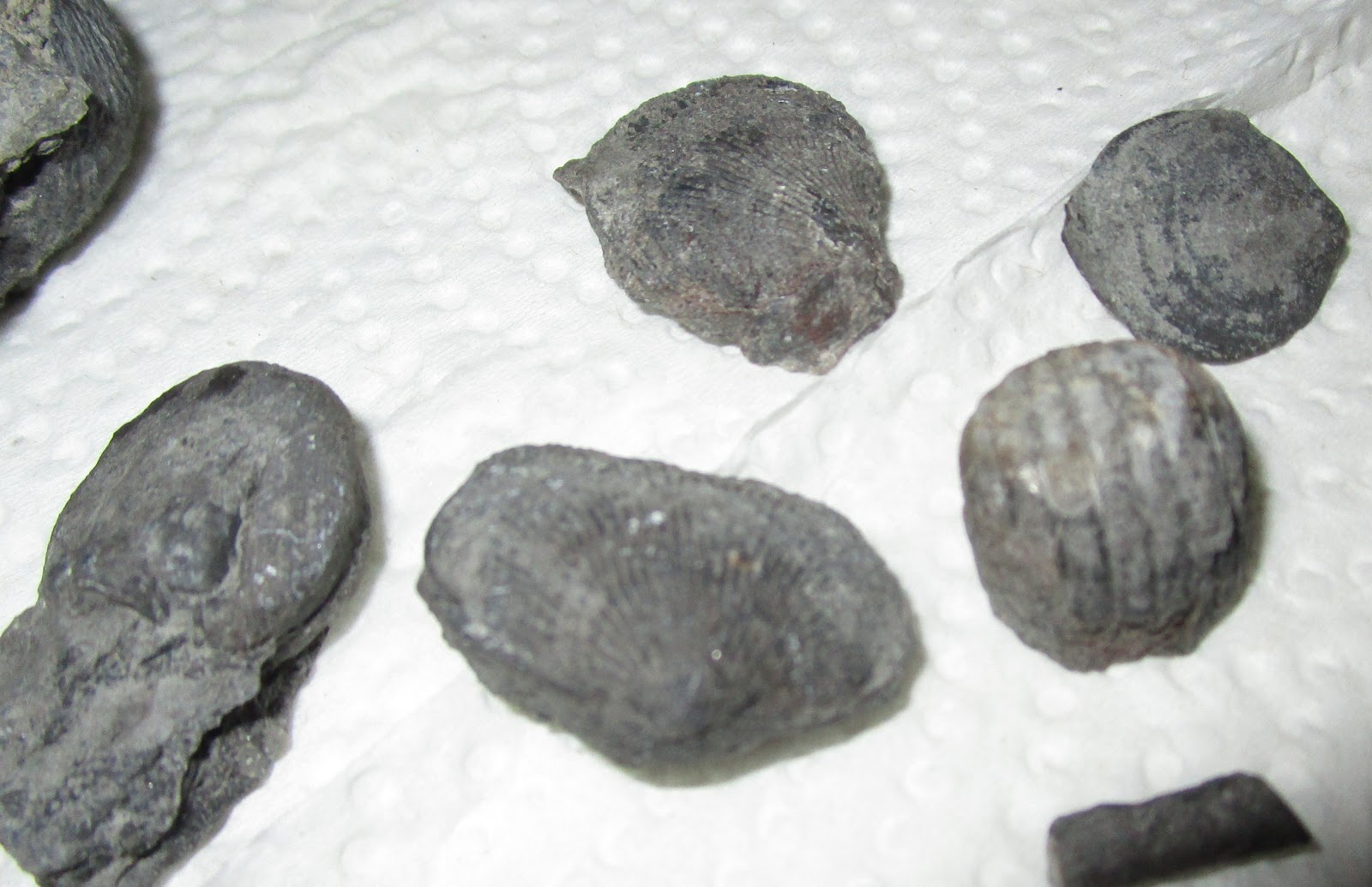
These are Devonian fossils from the outcrop described in this post; it's right outside the little town of Schoharie, the seat of Schoharie County, and I've since spent a couple of pleasant afternoons picking through the gray sandstone and shaley "grit" to find the valves of Gypidula and Spirifer and Atrypa and an occasional gastropod, long-vanished denizens of the Devonian seas.
I really will try and post something more substantive if I can get the damn internet back this weekend.


Saturday, May 06, 2017

Living large in Methburgh

It's sad, but I looked at the masthead and realized that an entire month had gone by without new content here. I won't apologize. I've been busy in real life and, frankly, I don't have much more to say aside from incendiary rants on the rank idiocy of electing a transparent con-man, grifter, and narcissistic asshole as the chief executive of a popular democracy.

So, instead, I'm sitting at the wobbly table in the apartment over the garage of a rental house in a small town in upstate New York where I'm on loan to a pile driving outfit working on a big water-supply dam reconstruction project, eating cold General's Chicken out of the plastic container and waiting for the Portland Thorns match to start on go90.com.
The work is...work. It's just your basic pile-nannying, complicated only by the ridiculous demands the New York Department of Environmental Protection had put on the contractor and the crappy weather.

(Speaking of which; did you know that the New York State Department of Environmental Protection has its own coppers? Seriously. I shit you not. And here's the best part; they're just as fucking idiotic about dressing up like soldiers and looking all billy-badass as regular coppers. Seriously. Tree-hugger-billy-badass-coppers. Here they are, the DEP Gestapo, in all their billy-badass glory.)

Is that fucking ridiculous, or what? Sometimes I think our goddamn nation went utterly batshit crazy on 9/11/2001.

The locale is perhaps the most left-behind, shit-kicking rural, economically depressed part of the state, a place that isn't so much a has-been as a never-was. I suspect that the Schoharie Valley was always the butt-ass end of beyond, a place for people to go who had no place anywhere else. It's surely that now, and it's even money which is more irking; the lack of good beer or the lack of good coffee.

Luckily I was able to remedy that today; I went into Cobleskill to the Price Chopper (and you have to say that in the Ahnuld voice: "Geht to the Price Choppah!") and picked up a bag of Starbucks French Roast and a six pack of assorted local brews, heavy on the IPAs. The folks here in rural NY seem to slowly be catching onto the microbrew notion, but, sadly, the coffee...dear God, what a shitshow.

I managed about a work-week with the "best" this area has to offer - Dunkin' Donuts - but finally I needed caffeine, REAL caffeine. I dropped into a "Stewart's Store", the local stop-n-rob franchise, to find something stronger than the weak-ass donkey piss on offer at Dunkin'. I browsed the coffee counter glumly before spotting a green-plastic-trimmed silex labeled "Dark Roast".

"Is this really "dark"?" I asked the plump woman behind the counter. "That's the darkest we have." she grumbled, and I held the thing up to the light; the flourescent tube was dimmed, barely, but the thing looked like nothing so much as the contents of a kidney-replacement patient's catheter bag.

I sighed and poured myself a cup.
But that coffee issue is solved, Price Choppah, you ah the best in life!

I did spend an enjoyable hour or so browsing Catnap Books, the utterly wonderful little used bookstore in frenetic downtown Cobleskill. Prize of the day was a 1944 New York State Museum Bulletin #336, "Geology of the Catskill and Kaaterskill Quadrangles" complete with gorgeous colored geologic map of the Catskill region directly southeast of me.
The geology here is orders of magnitude older and more complex than our juvenile and simple brute-force geology of the Pacific Northwest. These are old rocks; Devonian, Ordovician, Silurian...the tribal names from Britain where they were first described and classified. Sediments from long-vanished seas; red shales, black siltstones, many different colors of "grits" (the archaic name for a silty sandstone or sandy siltstone), and many, many layers of gray sandstones.

The valley of the Schoharie Creek was once on the eastern edge of a great vanished ocean, a narrow sea between the continent and a volcanic arc that had rifted away from the landmass to the west. This was a torrid wet forest, the earliest known on Earth, dominated by the bizarre fern-like tree once known as Eospermatopteris and now as Wattieza. The conical bases of these peculiar trees (they aren't really "roots"; the description I read said that so far as the paleontologists can tell these fern-like trees had teensy rhizomeish suckers at the base. Windstorms in the Devonian must have been a panic...) were preserved when sandy sediment buried the forests and casted-up the stumps as they disintegrated.
This ghost forest was unearthed in the 19th Century, but the real excavations came with the building of the dam in the 20th. Several of the treestumps have been tumbled into a small rectangular gravel bed outside the Gilboa post office. There's a bunch more outside the general contractor's trailer at the jobsite.

Outside the geology the work is just the usual pile-nannying, and the weather has been cold and rainy, and, as I mentioned, the coffee is awful.

And the Thorns struggled to an unconvincing home draw.
It's midnight here, and I have to get up to go see my kid sister in the morning. But I've got some time on my hands this month, and I'll be back around this joint in just a bit.

Saturday, June 04, 2016

Calefaction

The moment I stepped onto the front porch I knew it would be a breathlessly hot day.


Friday had been very warm in the oppressively cheerful way the early summer days here are warm; in the sun the heat bears down like hot metal while the shady sunless patches are pleasantly cool. The real measure of a hot Oregon day, however, in just at sunrise. Today the sun rose on a flat, breathless sort of dawn. Pulling the air into your chest it felt dry with the scent of dust. Even the asphalt was still slightly warm underfoot.

It would be a hot day.

The Pearl District of Portland has, in the preceding decade, descended from being a rundown post-industrial hardscape of dreary warehouses and melancholy-looking duplex apartments to a shiny, happy bustle of steel and glass and carefully-hand-rubbed artisanry; cute little coffeehouses, precious retail outlets, many, many spas and salons.

The early-morning passersby were already in their hot-weather wear; shorts, brief tops, and sandals, for both men and women.

Why is it that a woman's feet in sandals look pretty and tended while men's just look...unkempt?

The same goes for our legs, unfortunately; most of the Pearl morning women were tender, neat, and attractive from the hips down...while we betesticled types ambled about in an ungainly shackle of knobby knees and hairy shins.

In my heavy boots and thick work pants I envied the gentlemen of leisure their cool shorts and open shoes, but not their bumptious look. I know my own appearance too well to pretend that I would look any less ridiculous in their abbreviation.

There was a single five-hour parking spot next to our work site, a city block being transformed into a wooden-slatted hole in the ground, now full of machinery and the debris of construction. I fiddled with the parking machine and then stopped to enjoy a lovely pedestrian, cool in her flowing white dress and (of course) tidy jeweled feet in tenuous sandals, her bell of iron-gray hair shining like a gunturret in the heavy sun.

She passed with a look, calm and pleased with herself and her morning, bound on who-knows-what errand or no business at all; perhaps merely "taking the air" on a Saturday morning.

I was what I call the "anchor nanny" today. It is, rather like highway driving, one of those appallingly awful tasks that combines the necessity of constant attention with a complete lack of intellectual or physical stimulation. It is bookkeeping, pure and simple; so many feet drilled, so much silt, so much sand, so much anchor length (how much bonded, how much unbonded..?), so much grout pumped.

Primary grout volume, secondary grout volume...the point of the exercise is simply to reduce the number of indeterminate variables when an anchor is tested and fails. That way the designer can decide whether it is the design that is inadequate, or whether the construction was defective, or whether - if both appear satisfactory - the failure was due to some sort of anomalous soil condition that no one could have anticipated.
The crew worked in the heat, roaring like their equipment, cursing and sweating. I moved, like one of those slow-migrating animals (a tortoise, perhaps, or a similar creeping reptilian thing), from west to east following the shadow of the superjacent building and the eastern wall until, finally I could retreat no further and the sun in its' loathsome splendor leapt overhead and I was sweating and cursing and stinking like the rest.

By midafternoon no one wanted to continue. One of the drills got stuck, the foreman breathed out one last fiery curse and shut the job down.

I still had an hour to go, completing my report for the day, but at least in the cool of the old mill building where my company has moved. There was also cold beer, and I could strip out of the heavy protective gear and into shorts, daring the empty office to laugh at my legs. It was late afternoon when I emerged to be punched; gasping, breathless, by the hot, heavy gold blanket of the dying day.


“Summer is the time when one sheds one’s tensions with one’s clothes, and the right kind of day is jeweled balm for the battered spirit."

~ Ada Louise Huxtable

Friday, February 12, 2016

A long time ago in an island arc not so far away...

I think this is an artifact of a 33-40 million year old earthquake that occurred in the old island-arc off Oregon that is now the Coast Range.


The lower (left in the picture) material was a coarse grained pyroclastic sand, probably deposited as an ash-flow in the shallow seas around the old island chain. At the time what is today's Oregon Coast Range was an offshore chain of volcanic islands, very like the modern Japanese home islands. These rascals huffed and puffed a lot of volcanic ash into the air and from thence into the Eocene seas off what is today the Pacific Northwest.

You can see that a layer of gray silt was deposited above it, but you can also see that the silt is broken in the middle and the orange sand has pushed right through it.

On top of the silt (to the right) the sand has flowed out onto the surface of the silt, making a layered mound; these things are called “sand blows” or “sand volcanoes” and are a typical surface feature of liquefaction during strong earthquakes.

Just my interpretation, mind you; if you have two data points and two geologists you will typically get eight working hypotheses. Still...one hopes that the Eocene building codes were being stringently enforced.

Oh, and what do you get if you have one data point and one engineer?

A regression line calculated to four significant figures.

just sayin'.

Friday, November 27, 2015

Stubbed Toe

See below; this is my reconstruction of the Santa Clarita landslide.


Typically large, slow-moving rotational slump- (meaning that the movement is rotational, with the top part moving down and in and the bottom (or toe) moving down and out) earthflows (meaning that the thing is moving slowly, like a big earth glacier) develop large toe-bulges at the bottom. Somewhere in my files I have a picture of an old mine access road that has been buckled up and rotated vertical by the toe pushing up and out at the bottom of a large earthflow; the thing stood straight up for about 8 or 10 feet. That'd have been a real sonofabitch to drive up with a stick shift.

I had a long discussion about this thing with my friend GeoChick, and I told her my problem was that all the articles had the scientific intelligence of a mophead. "Guh - landslide" was about the level of sophistication. Seriously; I couldn't tell either from the pictures or the text enough about the topography or the geology to even guess what was happening.

But long-time commentor Ael finally sent me a link to an article that showed not just the big honkin' road uplift but the surroundings, and it looks pretty clear to me that this thing is at or near the base of a slope that is failing, and it's pushing this road up because the road is at or near where the bottom of the slide plane "toes out" of the ground surface...

And this is a simple landslide. Given that, can you imagine how hard it is for most reporters to understand something as complex as climate change?

Thursday, July 16, 2015

Dark Waters

The month that we call January was a hard time for people who lived in the village they called Kutauwa, in the sand hills, at the edge of the dark forests where the great ocean of the west met the river.
The seas were often high and the winds were often strong, too high and too strong for the cedar boats that the people used to fish and hunt seal and sea-lion. The gray skies hung low and heavy with cold rain and, sometimes, even the skirl of white snow or ice that drove the cold through the seagrass capes and the sealskins into even the toughest of the people.

So January was a time to spend indoors, when you could, in the warmth and the smoky glow of the firepit and the comfortable fug of warm bodies. Let the cold rain beat against the cedar walls and the cold wind raise the white foam on the wavetops and spin the grit off the dune crests. January was a time for mending, for gambling and lying and boasting and telling stories. For lovemaking and quarreling and making up. The night came early and the dark and the cold made good excuses for taking the work and the food and the slaves inside to sit by the fire and tell stories.
That night her brother was telling stories. He was a good storyteller, and he was telling one of her favorite stories, his soft eyes glittering and his long arms dancing before him as he described how the strange, eerie seal had towed the seal hunters to a strange place:
"Now we have gone to a far place. Gone are the breakers; the breakers have disappeared now. It is just calm everywhere; the breakers have disappeared."
She loved how his voice hollowed out as he described the weird calm sea and made the happy shivers run up her back as she thought about the strange seal and the scary ocean far away. She hugged herself in eager anticipation of the rest of the story, happily frightened in the warmth of her sealskin and the cheery firelight.

So it was the emptiness as her brother's voice stuttered to a stop that shocked her more than the first light tremor that shook the roofpole behind her. Somehow the silence was more shocking than the loudest shout. The only sound was the crackling of the fir branch in the fire as she stared into her brother's eyes, now huge, and dark, and frightened.

And then the shaking came.

It seemed to her like she and her house and the whole world were taken up like a salmon in the mouth of su'ln the big brown bear and shaken, as the bear does, to kill. The horrible shaking went on and on and on. She was screaming but couldn't hear her own screams because everyone was screaming. From somewhere behind her she heard a grinding and a splintery crashing and some of the screaming stopped. Some, but only some, because the shaking still went on and on and the screaming went on and on and the horrible sounds of her home and her family dying went on and on.

Until they stopped.

She didn't know how long she was there, terrified and silent and still. It was her brother storyteller who found her, one of his arms twisted and hanging down, and pulled her up with the other, up and out not towards the door, because the door-end of the house was nothing now but a shattered wreckage of cedar planks and poles and bits of mats and baskets, but towards the forest-end where the walls gaped open to the dark. She struggled briefly until he pointed to where the flames from the scattered fire were running up the wall. Together they stumbled out of the opening into the misting rain and the night.

The clouds were thin enough and the moon was bright enough to see the village around them, or what remained of it. The great house of the headman was gone, a heap of shattered wood and worse things spattered around the huge fir that had fallen over it. More than half of the other houses had fallen or were leaning broken, or, worse, beginning to burn. In the wavering light they could see others crawling or staggering shakily from their homes, many still keening or weeping with fear.

It was the convulsive grip of her brother's hand on her arm that made her look up, then follow his face to the west, to the broad arm of the sea where it met the bay. Or where it had when they had gone inside in the sullen dusk. Now the water was gone. Dark sand gleamed wetly under the moon and the rain.

"Now we have gone to a far place." her brother whispered, "Gone are the breakers; the breakers have disappeared now. It is just calm everywhere; the breakers have disappeared."

She stared up into his face.


And then the breakers returned.

The waters rushed in upon them, rising, rising, never stopping, like some mad tide summoned by the gods. She tried to run but the waters were faster and knocked her down. She tried to hold on to her brother but the waters were stronger and ripped his hand from her arm, sank his face from her sight and his last cry from her ears. She closed her eyes and died.

Until the cold, hard bark of the great cedar slammed against the side of her face, shocking her awake and alive again. She gasped and clung to the trunk and then to the branch beside her, as thick as her waist and sturdy as a stone. The waters rose, and she climbed higher, onto another branch almost as large as the first. She lay on the wet moss and put her face into the wet softness, the cold rainwater washing away her hot tears.

She lay still as the dark waters rushed past her filled with soil and trees and the pieces of her life. She lay still as the waters rushed away home, sweeping with them all those things out into the ocean again. She lay still when the waters returned, smaller, weaker, but still higher than a standing man's head. Still full of bits of the dunes and the hills and the forests and more awful things; bits of baskets and furs and animals and people.

She lay still until the light came again, when the sky lightened over the mountains behind her, and showed her the place where she and all her people had been born, and lived, and now was no more.

Wednesday, April 02, 2014

Choking on silver

In case you wanted more doom and gloom (and talk about the weather, Ael...) here's two related news items laying out in excruciating detail the killing blow awaiting us at the top of the dark ramp ahead.

First, the near-certainty that we are in the process of baking our world to a delicate crunch.

And, second, that we are ensuring that our New Oligarchic Masters will not give a flying fuck about that.
And despite the furious verbal and written smokescreen that the meeching coterie of remoras for the wealthy and powerful will emit, these are related, and unless We the People act decisively and swiftly mean that those of us not insulated by wealth and power are headed for an ugly future.

Simply put, since the advent of the Industrial Revolution we've been transforming our planet not so much to an unprecedented degree but at a hyperkinetic rate. Our average global temperature has both risen and fallen significantly before this, but these were part of the larger global/solar system heat cycles.

What we've done has been, in effect, to add a heat wave to the vast swells of insolation, ocean circulation, carbon sequestration and release that affect the Earth and have pretty much since the damn thing cooled enough to accumulate an atmosphere.

We con't be sure how big this wave is relative to the swells. But we can tell that it's there, and that it has the potential - assuming that the overall global climate isn't dropping back into a glacial period - to drive our planet towards the kind of climate that makes grasslands of forests and deserts of grasslands, raises oceans and otherwise creates some pretty impressive changes in our local flora and fauna.

And the critical factor is that this is happening fast; a couple of hundred years, a flick of geologic time.

Things like our food crops are the products of generations of selective breeding, and our food-producing regions developed of millenia of human history. And the same history shows that when those crops and regional conditions change, as they did for the Sumerians, as they did for the Anasazi, that can get very difficult and deadly for the humans involved.


Unless...you have the wealth and power to insulate you from that change.

If you can move freely about the globe, if you can pay for your own sources of food, of heating and cooling, if you can pay for your own armies to secure those things and to defend you from those who don't have the wealth and power to secure them for themselves, well, then...why should you care?

Why shouldn't you be more interested in your short-term wealth and power? Why should you give a flying fuck what happens, then?

That's one of the huge reasons that oligarchy and plutocracy are bad for everyone outside the oligarchs, plutocrats and their entourage and, eventually, for them, too.

When you put that much wealth and power into the small group that also controls the polity you produce a perfect storm of ignorance and indifference. The aristos don't know how bad it is for the proles and don't care.
We know what the inevitable result is. The ugly mess shambles along until finally some sort of unholy disaster unhinges everything. The society disintgrates into a war of all against all. The usual conclusion is either the ascent of a strongman, a Lenin or a Napoleon, or a descent into anarchy and barbarism as after the fall of Rome.

And for some reason we've managed to construct this meatgrinder and are ramming our collective dicks into it while we worry more about missing airliners and white girls and who's got the inside lane on this season's reality show.

I have absolutely no idea what the fuck to say about this except the dinosaurs had the excuse that their brains were the size of a fucking walnut.

Monday, March 31, 2014

Deep Denial

You have probably at this point seen something about the immense landslide that buried portions of the small western Washington town of Oso.


I should say here that while I didn't know this specific locality or the geology of the particular hillside involved that the news didn't really surprise me. And that, frankly, it shouldn't have surprised anyone else, including the people in the little town that woke up last week to find themselves very much dead.

Tim Egan has a good summary of the geology and the politics behind the deaths here. I can't really do much better at describing why these people were buried than he does:
"...who wants to listen to warnings by pesky scientists, to pay heed to predictions by environmental nags, or allow an intrusive government to limit private property rights? That’s how these issues get cast. And that’s why reports like the ones done on the Stillaguamish get shelved. The people living near Oso say nobody ever informed them of the past predictions."
As Egan points out the "problem" is not the science. We knew what happened, why it happened, and why it was damn likely to happen. The geology is pretty straightforward; western Washington (and parts of western Oregon but the Puget glaciation makes things an order of magnitude or three worse in WA...) combines steep terrain, lots of water, and weak substrate into a deck full of pretty deadly cards.

Throw in clearcut logging and you have a real wildcard in the deck.

No. The "problem" was and is really the suite of massive problems surrounding the politics of this region and of a hell of a lot of the way we Americans think in general.

First, a whole lot of rural western WA is pretty much logging and nothing else. If you close, or limit, the logging in the steep timberlands around these little towns then little towns like this Oso just flat-out die anyway. Only without the, you know, actual dying.

And then there's the question of "private property rights". A hell of a lot of the sorts of people who live in this little town, including the ones now buried under a shit-ton of hardening landslide debris, believed that they had the absolute right, and that the timber companies had the absolute right, to do absolutely whatever they wanted to do on "their" lands. And that to do anything to change, or stop, those people and companies doing those things was wrong.

So that while a whole hell of a lot of people knew that this hillside was unstable, and that logging around it was problematic at best, and that the possibility for the whole goddamn thing to move downhill on top of these people's houses was not so much a question of "if" as "when"...nobody actually pushed someone to do anything about that.

In this case the nobodies and someones involved would have had to accept that 1) there are limits, and deadly sharp, critical, limits on our human ability to fuck about with natural systems, and 2) that it is in humans' best interests to have an overall authority - let's call it "government" because, really, what the hell - to define and enforce restrictions on that human activity before it crosses those limits.

And rural western WA and a hell of a lot of today's United States is full of people who accept neither 1) nor 2).

So this one falls under the general heading of, what's the quote, something like "The willingness of someone not to believe something is directly related to how critical it is to their perceived self-interest not to believe it."?

They saw their self-interest as "private property rights" and "limited government" and not "natural hazards" or "regulation".


In order to believe that they had to deny that this could happen.

And then one morning their denial rose up and buried them deep.

Wednesday, January 15, 2014

108 Years of Silence

Fascinating collection of composite photographs of San Francisco; juxtaposing scenes from the city today with the way they looked after the April morning in 1906 when the world changed for the City by the Bay.


Lovely, and yet ominous.

Living on the edge of the great abyss as we do here in the Pacific Northwest we often ignore how close we all live to the Day of Wrath. Our own fault, like the San Andreas, the Garlock, the White Wolf and all the others, waits silently with the patience of all true predators for the moment that it is no longer patient, the moment when it will reap whatever it will.

Friday, August 16, 2013

Damn, I'm good

There are all sorts of things I'm not very good at.

It's not that I don't do them, or like them, but a lot of the things I do and like to do I'm just not very accomplished in. I cartoon, but not like a real cartoonist and write but not like a real writer; nobody would pay me money to draw or write for them. I'm fascinated by history and military history (as you probably know) but nobody would hire me as a professor of history or to lecture on the Battle of Khalkhin-Gol.


I love to sing but I'm not a very good singer. I adore my bride but nobody ever confused me with a Great Lover (though I practice as much as she encourages me to...). I love my kids but will never be Father of the Year.

I still try and play soccer and lacrosse to the extent my hip will let me, but I was never better than a mediocre amateur player in either one.

I can cook a mean feojoada but I'm not good enough to be line chef at Denny's.

So I'm no different than most of any of us; I can whittle a bit, splint a fracture, ride a motorcycle, sew a seam, discuss a play, give a foot massage, be gracious when complimented, argue a point, paint a fence, share a companionable silence...but only to my limits which vary from severe to trivial.

But one thing I can do; I can do geology.


Late this morning one of my engineers asked me a question; "What's the age range of Holocene (that is, younger-than-10,000-year-old) sedimentary deposits in the Grays Harbor region of Washington State?"

Now I gotta tell you; I know from squat about the Holocene deposits in Grays Harbor. Never worked there, never really studied the place.

But.

I DO know who has. And so I started chasing down the work of Brian Atwater and Curt Peterson, two geologists who have studied the impact of tsunamis on the Oregon and Washington coast.

When the Cascadia subduction zone detonates it typically does two things; it drops the coastline down anywhere from a couple of feet to a couple of meters, and it generates a big wave, a tsunami, that washes over the now-lower-coastline. This is usually preserved in the stratigraphic record as a layer of ocean-bottom or continental shelf sand over organic bay or even upland deposits. The old forest (or coastal swamp) is dumped into the ocean and then the big wave dumps the sand on top. Oh, and after that there's usually a slow uplift, so above the tsunami sand you get tide flat mud or even marine or beach sand that slowly gives way to upland soils and topsoil.

The two guys Peterson and Atwater have been studying this since the 1980s, and in the process have had to do a lot of drilling and coring along the Oregon and Washington Coasts. So I figured that if I tracked down their research I'd come across something that would point me in the right direction.

And as it happened, within twenty minutes I'd pulled up Peterson and Phipps (2012); a study that gave a direct correlation between sediment depth and age at Grays Harbor.

I provided the information to the engineer less than an hour after he'd asked the initial question.

Life has provided me with the usual number of censorious looks, shaken heads, pursed lips, and drawn-down brows. I've had my normal share of being laughed-at, bitched-out, and cussed at. I tend to think of myself as, I suspect, most mentally-healthy non-flaming-asshole people do; a mixture of accomplished and incompetent, a middling-sort of person with no more than average gifts.

But every once in a while I'm afforded a wave of pure satisfaction; every so often I scare myself by being extraordinarily good at something. Geology is one of those things.

I may never be a great artist, or lover, or leader, or singer, or father, or husband, or human being.


But geology?

I'm like a fucking Zen master at that.

Wednesday, August 14, 2013

Today and Yesterday

We had nothing else to do last Sunday so I pulled out the shotgun, forced the wife and children into the Subaru, and drove out to the eastern edge of the Coast Range to go fossil hunting.

To be exact, we went to two of the locations shown on the map to the left: first, to #6:
"A fossiliferous outcrop of the Keasey Formation occurs in a prominent cut along the Nehalem River on the east side of the road from Timber to Vernonia, 3.0 miles north of the junction with Sunset Highway. The locality is about 3 miles south of Locality 5. Large pelecypods of the genus Thyasira are found at this outcrop."
And, sure enough, that's just what we found.

The little peeps were excited about finding fossils but what was fun was watching them get excited in their own ways.

Little Miss stuck close to her mama, working the talus at the base of the slope along the highway, patiently looking over every rock and shard, exclaiming in her high little voice every time she found a bitty fragment of white shell or rounded thing that looked like a clam shell.

The Boy scampered up the hill right behind me, poking here and there but really wanting something big and gaudy. He got his shoes completely filthy.

Fortunately for both of them Daddy had been there before and knew right where to look to find the Good Stuff.


That's a Thyasira Missy's holding; a 23-million-year-old chowder clam.

Here's both the urchins with some of their finds:


The other visit was to "Trestle Quarry", stop #8 on the map, which is described in Steere (1957) as
"An abundantly fossiliferous zone in the Keasey formation is exposed in the cliffs at both ends of a high-curving railroad trestle which crosses Oregon State Highway 47 between Sunset Highway and Vernonia. The trestle is 6.2 miles north of Sunset Highway and about 8~ miles south of Vernonia. There is a parking space beside the highway at the base of this trestle. To reach the fossil localities at either end of the trestle climb a steep foot trail to the railroad bed above and continue along the tracks for a short distance. Many well-preserved fossil shells of Oligocene age may be collected from outcrops along the railroad. Fossil crinoids have been discovered at both ends of the trestle. About .2 mile beyond the north end of the trestle and adjacent to the railroad is the Smithwick Haydite quarry in which Keasey shale is freshly exposed and fossils are unweathered. Permission should be obtained to hunt for fossils in the quarry."
Yeah, well, that was then.

Today the old railroad grade is part of one of those rails-to-trails parks, and the State of Oregon has put the old quarry off-limits to fossil hunters. I found that out the hard way when, taking my Portland Community College historical geology class up there one autumn I was stopped, lectured, and cited by Mister Ranger. Somewhere I have the ticket I was issued warning me that if I was ever caught fossil-red-handed again I'd be fined and presumably spanked by the Parks Fossil Nanny.

Curiously, since my fighting-the-Fossil-Law-and-the-Fossil-Law-winning the Parks people have evidently give up trying to maintain the trail through the old quarry site. A new, fancy paved trail leads up the bluff and skirts the old quarry and the abandoned railway grade.


The forest is reclaiming the trail and the quarry. There isn't even a sign posting the old trail and adjacent high slope as out of bounds, and both are now very untenanted and becoming overgrown...


...and even the talus along the trail was pretty lean pickings from the glory days of yore when I came back from the trestle with the Dentalium, Thyasira, and Anadara that now sit patiently on my desk waiting for me to return from the field...


But for all their moaning I think the kiddos had fun. I did, oddly, exercising a skill I seldom use anymore and teaching younger people about the yesterday buried deeply in the voiceless hills and silent slope we speed past on our way to some urgently transient today.

Saturday, December 08, 2012

Friday Jukebox: Continental Drift Edition


Björk rocks the spreading center; geology as art - how cool is that?

(immense h/t to Syrbal at Herlander Walking for this awesome video)

Thursday, November 01, 2012

Diktytaxitic

I was wrapping up for the day today when this word popped into my head.

FYI, one of the things I love about geology is the language. We are a very "wordy" science; the original geologists back in the Victorian times spent most of their time describing stuff. It's only lately that we've gotten more quantitative like, well, real scientists.

Anyway, our basalts - and we have LOTS of basalts around here - tend to have this; it's...well, in Fuller (1931) this word describes "Microscopic (<2.0 mm), irregular intercrystalline voids and outlined by crystal faces of adjacent groundmass minerals" which simply means that the rock has lots of teeny holes in it, like this one:


The little white things, like the small triangular space at the bottom center? Holes. Voids; small spaces in the rock made during cooling from the hot hellbrew (magma, or lava in this case...)

Here's what it this "diktytaxitic texture" often looks like in hand:
Cool stuff, basalt.

Anyway, now you know about "diktytaxitic". Good luck next time you play ScrabbleTM!

Friday, July 13, 2012

Friday Jukebox: Improbable Paleontology Edition

Because if you reeeeally want me to keep posting the kind of stuff that tickles the ass offa me...
...well, here it is.

Yeah, I know - somewhere some Christian school is using this video for a teaching aid. Sigh. And it was the dinos that went extinct. Go figure.

Aaaaanyway, speaking of dinos, first, I should really credit the indefatigable Chas. Pierce, from whom I stole both the awesomely-Eighties Was (Not Was) video and the link to this website where you can find out all sorts of things you probably either didn't, or didn't want to, know about dinosaur sex.
Because when they taught you about dinos in school they left out the part where the ankylosaurus tended to roar "Yes! Yes! Ride me like a little pony!" and the ceratopsians were known to prefer dressing in kōkōsei gyaru outfits.

And, yes, this is just another application of Rule 34.

Thursday, July 12, 2012

Shearly stupid

After two frantic days of back-and-forth with the test equipment supplier Humboldt I finally got the Direct Shear test software "registered" (which involved repeated trips across the parking lot with the lab computer on a wheeled trolley to hook it up to the internet). Wheeled the machine BACK to the lab, reconnected everything to the actual shear device, input all the sample, project, test parameter data into the application, clicked on "Run Test"...and...nothing.

So...frantic rechecking every input and connection, adjusting parameters, attempt to start shearing motor manually fails, weapons-grade cursing everyone and everything from person who invented the goddamn direct shear test, to Humboldt, to James Watt for having encouraged people to mess about with goddamn science...at which point I notice the Big Red Emergency Stop Switch is pushed in, disconnecting the motor.

Gently pull BRS to "off" position. Recheck parameters. Click "Run Test".

Test runs.
I feel 120% stupider now than I did twenty minutes ago.

Boring and more boring

I couldn't just leave you with the story of Mount Tabor; the Boring Lavas are all over my city, and they are, like, the kewlest pre-Holocene underburden EVAH!
First of all, there's The Great Mystery, which is;

We have no fecking idea WHY the things erupted in the first place, why they started when they did, and why they (at least apparently) stopped.

Now the Pacific Northwest is volcano Disneyland. No argument there. The only thing you really need to know about plate tectonics is that there are three basic types of ways that the ginormous shell-bits that clad the outside of the Earth interact.
There's places that the plates are moving apart - these are spreading centers or divergent margins, and they are where new crust is made. Most of them are along the bottom of ocean basins, which is why they're often called "mid-ocean ridges".
They have pantsloads of volcanism but their earthquakes are typically small. Iceland sits right across one, but there is no active spreading center in or nearer the continental U.S. than the Gulf of California.

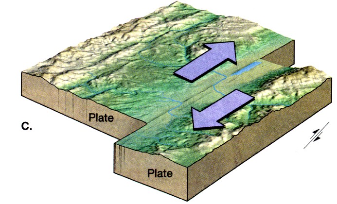
There are places where the plates move past each other - these are transform boundaries and you probably know of one right off the top of your head. The San Andreas Fault Zone is a monster transform margin, with Southern Californa (which is really part of the Pacific) moving northwest relative to North America.
These sorts of margins - despite what the movies will tell you - almost never have volcanoes. Instead, as you probably already know, too, they have huge earthquakes.

But here in the Pacific Northwest we live next to the third kind of plate margin - the one where the plates are moving together. This is called a convergent margin and comes in two flavors. Where continent meets continent you get the world's biggest head-on, and the rocks pile up into a big ol' heap; think the Alps, or the Himalayas.
Where continent meets ocean, like it does off the Oregon and Washington coast, you get some big-ass volcanoes - "stratovolcanoes" - the biggest and meanest of the breed. These things are second only to what are called "calderas" for explosive power, and they tend to get real vindictive to those living around them. Ask ol' Harry Truman, the lodgekeeper of Spirit Lake. Oh, wait, you can't - Harry's buried under several million metric tons of Mount Saint Helens that exploded all over his cranky old ass back in May, 1980.
But the other part of the deal is that these rock plates are also ramming together. They tend to get stuck for long periods when nothing happens.

But then they move.

And it's real wrath of God stuff; buildings fall over, the dead rising from their graves, dogs and cats living together.

Ginormous earthquakes, possibly the largest on Earth.

So. Okay, my family lives in Natural Disaster Central.

But getting beyond that; the thing is that we pretty much understand how we get the big stratocones. The ocean crust gets shoved down into the hot mantle, melts, mixes with and melts granite continent crust as it rises and erupts as a mixture of ocean basalt and continental granite - we call the stuff andesite, and there's tons of the stuff all over the Cascades.

And I've told you about the Columbia River Basalt, the incredible thickness of flood basalt that forms much of the bedrock everywhere around the Portland area.

But the Boring Lavas are very different.
First of all, as John Allen said, that
"as compared to the Yakima, (Boring Lava) is gray rather than dark gray to black, and the jointing is generally massive or blocky rather than columnar or brickbat. Still more characteristic of the Boring Lava, as seen in thin section, is the meshwork of minute plagioclase laths (polotaxitic texture) commonly with open spaces between the laths (diktytaxitic texture). The Boring Lava contains olivine, rare in Yakima Basalt, and there is a very distinct geochemical difference between the two types of lavas" (Allen, 1975, Volcanoes of the Portland Area, Oregon: State of Oregon, Department of Geology and Mineral Industries, The ORE-BIN, v.37, no.9, September 1975)
Boring vents tend to be either "shield volcanoes" or cinder cones rather than flow basalt like the CRB or stratified cones like Cascade volcanoes.

But - again - the big mystery is - why here?

Cascade volcanism is directly related to the tectonics of convergent margins. We think the CRBs are the product of a superheated geyser of magma from deep in the mantle - a "hotspot" or mantle plume.

But the Borings?

Their location and rock type suggest they're related to convergent tectonics, but that's like saying the Mitt Romney is a cluelessly entitled gasbag because he comes for a family of rich Mormons - it's a condition, not an explanation. Don Swanson admitted he was pretty baffled:
"The setting of the basalt field is puzzling and not understood. The vents lie well west of the crest of the Cascades, and those such as Kelly Butte, Mount Tabor, and the vents in the Portland Hills are in and even west of the Portland basin." (Swanson and others, 1989, IGC Field Trip T106: Cenozoic Volcanism in the Cascade Range and Columbia Plateau, Southern Washington and Northernmost Oregon: American Geophysical Union Field Trip Guidebook T106)
They do seem to be related to fault lines or fractures in the Portland Basin, where magma can leak through. They might be a sort of "forearc" volcanism, similar in nature to the small spreading basins that sometimes form between the subduction trench and the volcanic arc it generates.

But, honestly?

We're not really sure.


We're also not sure of why they started erupting - about 2.7 million years ago - and why they stopped - in some cases, less than 300,000 years ago.

The big Cascades peaks; Hood, St. Helens, Rainier, Shasta - are all about a million years old. The older rocks, the so-called "Western Cascades" that underlie the big stratos, predate the subduction of the Pacific rise at the western edge of the old Farallon plate at about 40 million years ago and shut off about 5 million years ago, near the end of the Pliocene.

So what happened 2.7 million years ago to kick-start the Boring Lavas?

We have no idea.

Either.

But we do know that the Boring Lavas provide us with some of our most beautiful scenery and our most attractive places, from Mount Tabor to Elk Point high atop Sylvan Hill, from Larch Mountain in the east to Bob's Mountain up north.

One of the best places to see the Lava is, not surprisingly, down deep in the earth; in the Oregon Zoo/Washington Park station of the west side MAX light rail line.

Here the Tri-Met designers placed a portion of one of the rock cores that Portland geotechs L.R. Squier drilled back in the Nineties for the tunnel that runs through the West Hills; it does a wonderful job of showing you not just the Boring Lavas themselves but their relationship to the older, and younger, rocks and sediments that make up the bones of our Portland earth.
There's a couple of terrific blog posts about this trolley stop; here's a great one, by the delightful Dana Hunter over at En Tequila Es Verdad, complete with a full-contact geologic discussion of the B-5 core on display. Dana utterly rocks the rocks, too - she's a manic for geology, and her blog has a ton of other great geo stuff for your delectation.

Here's another, from the blog Subway Nut; Jeremiah Cox, the blogger, is more into the actual train station than the geology, but his pictures of the core there are incredible...
And most splendid of all, here's the U.S. Geological Survey's cross-section through the West Hills; it's amazing, and - like many of the wonders in life - the pink parts are the best.
In this case they're the fantastically convoluted layers of Boring Lava over on the east flank of the Hills. Here's the explanation of where they came from, when, and what they look like...
There's not too many places that can actually enjoy having volcanoes in their downtown, just another reason why Portland is the goddamn greatest People's Republic on the North American Plate.
Viva los Erupciones!